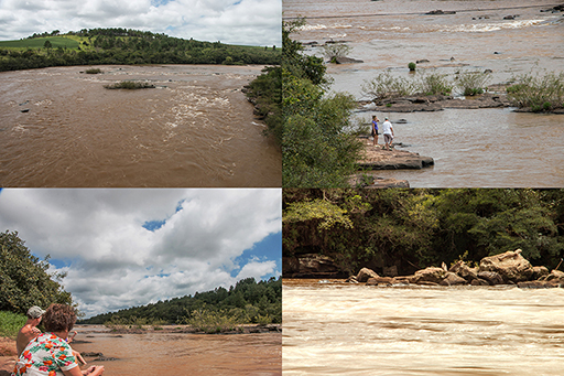
he Tibagi River has its source on the slopes of Serra das Almas, in the Palmeira municipality, at an altitude of 1,100 meters; it empties into the Paranapanema River at an altitude of 298 meters, and is about 550 kilometers long. Today its course ends in the waters of the Capivara Dam, where it runs the turbines of a hydroelectric plant built by Companhia Energética de São Paulo (CESP). Its higher course develops in the middle of Campos Gerais. On its right bank, the Tibagi receives the Cajuru, Guabiroba, Cará-Cará, Ronda, Taquari, das Conchas, Pitangui, and Iapó Rivers. The Quero-Quero, Pugas, Caniú, Santa Rita, Guaraúna, Imbituva, Bitumirim, Capivari and Imbaú Rivers are left-bank affluents.
In some stretches, the high Tibagi runs through canyons. In its navigable stretch, the river varies from 100 to 900 meters in width. At its mouth, before the Capivara Dam, it is 2,055 meters wide and 2.48 meters deep at the talweg. The substrate of the Tibagi is very irregular, with cauldrons and potholes formed by water erosion. Eventually it is cut by dikes of diabasio, a volcanic rock which fills fractures. These dikes are associated with the innumberable rapids which occur along the river.
In a land travelled for thousands of years by indigenous populations, then occupied by the Spanish and the Jesuits and their reductions; in a land whose numberless land and water routes were intensely walked and navigated, there arose the settlement of Tibagi, which adopted the name of the legendary river crossing Campos Gerais south to north. Miners and adventurers, attracted by reports of a river full of diamonds, stayed camped on its banks, waiting for the water to lower enough to allow prospecting. They planted vegetable gardens for sustenance, raised animals, built wattle and daub houses. Serra da Pedra Branca was the main focus. Two guards were kept there in the 18th century; they watched over the control of the mines and defended against the natives. The first remained camped at the mouth of the Capivari until 1765, and came to be called Guarda Velha, when Porto de São Bento was created to give security to the military expeditions of Afonso Botelho.
When Antonio Machado Ribeiro was given possession of those lands in 1794, the area was identified as Paragem Pedra Branca e Guarda Velha. Machadinho, as he was known, had been the right arm of Coronel José Felix da Silva, of Fazenda Fortaleza, in the fighting against the natives. He installed himself and his family in the place where some minors had already settled and where today stands the city of Tibagi. On the other bank of the river stood the fazendas of Lieutenant José Gonçalves Guimarães (Fazenda Guartelá) and Lieutenant Coronel Balduíno de Almeida Taques (Fazenda Igreja Velha).
Under the denomination of Guartelá, the Second District of Vila de Castro was created in 1833. A Justice of the Peace was named to attend to the region’s conflicts. Two years later, on January 9, 1835, Manoel das Dores Machado (son and heir of Machadinho) gave land for the building of a chapel consecrated to Nossa Senhora dos Remédios. It was his intention that all the land around the chapel be filled by streets and houses of all those who whished to live there. The Capela Curada, a rustic wooden building, was ready in 1836. It held a clay image of its holy patroness.
A few years later, the Barão de Antonina contracted John Henri Eliott, a surveyor and topographer, to plan the streets and patios. Eliott designed 110 x 110 meter residential blocks of lots, each block separated by parallel streets 12 meters wide. He differentiated the commercial blocks, which were half the size of the residential blocks. They flanked the main street, which crossed the Tibagi River in the direction of the church, thus making use of the traditional route of the region’s inhabitabts.
In 1846, the Parish of Nossa Senhora dos Remédios de Tibagi was created in the Castro municipality. In 1872, the parish’s status was elevated to that of town, and in 1897, the town officially became a city.
The name Tibagi comes from the Tupi idiom. One of the accepted definitions of “tibagi” is “river of rest”. On the other hand, research carried out by Edmundo Alberto Mercer concluded that the term means “river of many falls”, or “river of rapids”. The French naturalist Auguste de Saint-Hilaire had already translated it as “axe factory” (tiba = “factory”, e ji = “axe”). It is worth considering that one of the ways of attracting natives to the Jesuit “reductions” was the offer of iron axes. The wooden axe was an essential tool in Guarani culture. It was used in farming and in the building of canoes. The iron axes of the Jesuits were a great advantage to those who came to the “reductions”. There may be a correlation between this custom and Saint-Hilaire’s 1820 interpretation.
click on picture
to enlarge